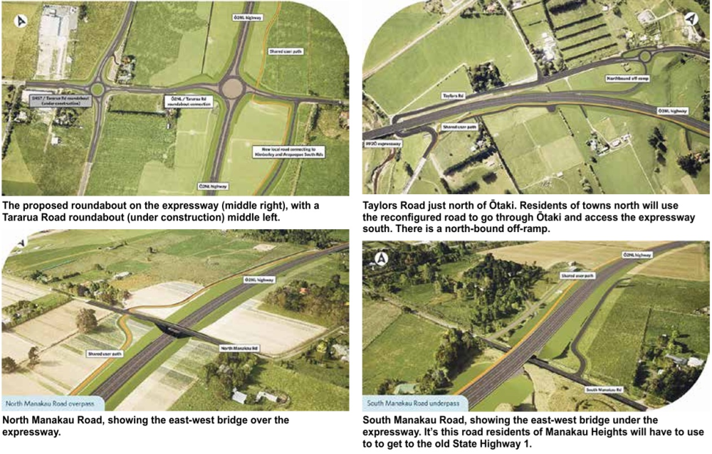
The NZTA images (bottom of page) illustrate the key aspects of the just released changed layout for the Ō2NL expressway.
Top left is the proposed roundabout at Tararua Road, Levin, (previously intended as a full interchange). NZTA says the roundabout is a cost-effective option that will provide full connectivity, allowing traffic to enter and exit at Levin, as well as maintaining the east-west connection for locals and access to the future Tara-Ika growth area.
Others are not convinced, saying a roundabout will slow through traffic and create safety hazards.
Top right is the equally contentious Taylors Road at the other end of the Ō2NL expressway, just north of Ōtaki. It’s where the current Kāpiti expressway will join up with Ō2NL.
Anyone coming from the towns south of Levin will need to use Taylors Road to go through Ōtaki and on to Ōtaki Gorge Road to connect with the current expressway south (or go north at The Ramp just north of the Ōtaki shopping area).
There is a north-bound off-ramp from the expressway, which will be an option for residents on the north Ōtaki Plateau, and an exit for people at Manakau, Kuku etc. The current Taylors Road will connect directly to old SH1 (currently blocked).
The two bottom maps show the proposed overbridge straddling the expressway on North Manakau Road. Next to that is the South Manakau Road underpass, which will go under the expressway.
Manakau Heights residents had believed they would have an overbridge that would connect them to Manakau village and beyond – that’s all changed after NZTA advised the Manakau community at a meeting on Sunday that the bridge concept was gone, the victim of cost-cutting. They will now have to drive to Manakau South Road and out to what will be old State Highway 1 to get to the village.